Cyprus Field Trip
Day 6 - 24 March 2015
Objective – to study the geological history of Cyprus following the cessation of ocean floor volcanism. In particular to consider:
- geochemistry leading to umbers and radiolariums
- generation of sedimentary rocks – chalks, flints, sandstones and conglomerates
- uplift processes that created the island
- erosion processes – both on land and submarine
- current creation of beach rock.
Time Scales:
Late Cretaceous:
- cessation of ocean floor volcanism
- Cyprus microplate rotating on the ocean floor
- Start of accumulation of deep water [pelagic] sediment over microplate – firstly chalk.
From 55 mya – early Eocene:
- microplate ceased rotating
- Tethyan Ocean closing
- compressional convergence forces causing thrusting and faulting with folding of sediments.
From 30 mya – early Miocene:
- more convergence and a subduction zone re-initiated to south of Cyprus microplate
- uplift of ocean floor and more sedimentary successions including shallow water deposits.
By 8 mya:
- shallower ocean floor with coral reefs
- continued uplift and parts of floor emerging above sea level to form 2 islands of Kyrenia and Troodos
- erosion of new land starts with fragments incorporated into developing marine deposits.
5 mya:
- former Tethyan ocean ie Mediterranean sea dries out due to evaporation and landbridge at Straits of Gibraltar. Led to massive gypsum beds [not seen on fieldtrip]
- subsequently sea returned with more sedimentation of mainly water gravels over the microplate.
Recent:
- intermittent uplift continues – evidence of incised water courses and raised beaches.
- convergence and subduction still going on with underpinning of Cyprus by a sea mount to the south
- earthquakes a regular feature.
Field work by location
6 locations to the east of Limassol. See map in Excursion Field Guide[EFG page 45] On page 46 is a geological column of the sedimentary strata from the Cretaceous to the Recent giving both the detailed succession and their correct names
The simplified description by location that follows is to highlight the main ideas picked up from Paul. For a more accurate fuller analysis please refer to pages 47 to 51 of the EFG.
Location 1a
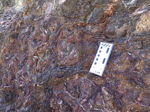
Quarry setting view of pillow lavas, with veining caused by sea water penetration. This represents the top of the volcanic pile 92mya and on the seabed at 4 km depth. Evidence too of mini pillow lavas and lava breccia giving a sedimentary infill.
Location 1b

Nearby above the pillow breccia, the dark brown deposits are umbers or mudstones made up of ferro – manganese from the lava below. They also contain radiolarites or deposits derived from the microscopic remains of radiolarians [or single celled amoebas] that lived in the silica rich oozes also exhaling from the still hot new crust.
Also introduced to olistoliths and olistostromes. To quote Paul's definition in the Geo-dictionary on the CD, an olistostrome is a sedimentary deposit composed of a chaotic mélange of heterogeneous material, such as blocks and mud, known as olistoliths, that accumulates as a semifluid body by submarine gravity sliding or slumping of the unconsolidated sediments. In other words there is a melange of mixed up items moved by gravity under the sea.
Location 2

A view of a hillside across the road. Here could be seen grey/brown clays with large blocks of coarse sandstone rocks embedded in them. The latter are again olistoliths from fault -scarp breccias related to the Troodos microplate rotation. The whole is called the Moni Formation
Location 3
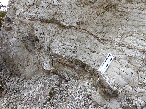
Beach and low cliffs at Governor's Beach.
Here we could examine the chalk of the Lefkara formation formed on the sea floor from the fragments of coccoliths or 'carbonate snow'. This chalk has been fractured by tectonic activity which created the fold and thrust belt 15km inland.
Silica rich water continues to generate radiolarites in the form of chert layers within the chalk.
Increasing clays within the Lefkara are evidence of basin shallowing with more input from the flanks.
Beach sand formed from olivine [hence green colour], quartz and limestone sourced from weathering of the ophiolite [with black bits from the mantle] and later limestones. Above sand, low cliff of beach rock consolidated from anything available including plastic bags and a flip -flop! Edge of adjacent car park has a calcium carbonate crust – simple cementing that can take only 2/3 weeks in hot weather.
Nearby a raised beach is evidence of more recent episodic uplift of the island
Location 4

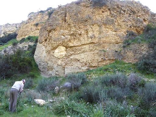
Road exposure near Four Winds.
Here we have about 15m of well bedded chalk with many chert layers. The chalk horizons [from the middle Lefkara Formation] show coarser basal elements grading upwards to finer elements. We are aware of similar grading arising from turbidites ie flow of land derived erosion material down submarine slopes. Here we were looking at calciturbidite deposits where deep ocean calcareous deposits have been deposited by turbidity flows moving material from submarine platfoms or shelves. Indicates bottom currents are involved deriving from the onset of tectonic activity.
Discussion of evidence of possible cyclicity in radiolarians giving rise to chert deposits, for example linked to Earth's nearness to sun, so warmer currents in basins. Episodic sediment loading on margins and seismic instability play a role too.
Talk too of birth of Cyprus by uplift partly caused by extent of serpentinisation of Hartzburgite rock which creates a less dense rock.
Location 6
Choirokhitia Gorge – 2 sites.

First one showed a significant cliff with a mid level unconformity. Above were jumbled deposits, including clasts of Pakna reef limestone, and on top of these were conglomerates. Below were more grey/blue Pakna limestone but this time visually different as these had been hydraulically altered by submarine water pressure [but how?]
The second site showed the clear impact of different erosion regimes. At the lower levels is a 2-4mya Pleistocene sub marine steep slope debris channel possibly following an earlier fault line. This is a fragment of Miocene sea floor topograpy. Above this area is a 10m band of gravels and fanconglomerates with 'clasts of everything' derived from the Troodos and from various limestones and chalk. This is now being eroded by the present river. The presence of various clasts are clues to episodic uplift relative to times of deposition.
Archeology

The day was completed by a visit to the World Heritage Neolithic Village site at Choirokitia. The village dating from about 6800BC is cut into a steep slope of Pakhna limestone.
More detailed information sources from Paul Williams – in ascending order of complexity!
- The Making of the Island of Cyprus – a Geological Overview. Recommended introduction.
- The Geology of Southern Cyprus – images, narratives & videoclips on CD.
- Excursion Field Guide to the Geology of Southern Cyprus.
- A Guide to the Geology of Southern Cyprus – a demanding hard copy text!